Scenic Drives Around Lake of the Woods Worth the Trip
Did you know the Lake of the Woods area is absolutely full of a variety of wildflowers? It is estimated that more than two million orchids along throughout the area. One of the most popular of course is the showy lady slipper. Named the state flower of Minnesota, the showy lady slipper is very rare throughout other parts of the state, but abundant around Lake of the Woods. 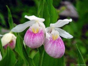 History of the MN State Flower.
 More than two million orchids blanket the Lake of the Woods area. To catch a glimpse of these beautiful flowers, you’ll begin at the Lady Slipper Park in Williams, go through the town, then head west out to Blueberry Hill, located on the south side of Hwy 11. Please remember that it is illegal to pick or uproot the Showy Lady Slipper in Minnesota. However, you’re welcome to ”take” as many photos as you’d like!
For a free Wildflower Route Brochure and route map, just contact Lake of the Woods Tourism.
A century ago, the ostentatious Pink and White Lady’s Slipper was a favorite adornment in rural church altars during the summer. Since 1925, this rare wildflower has been protected by Minnesota state law. In fact, it’s illegal to pick, uproot or unearth the flowers. The best way to enjoy them is to see them, smell them and take pictures of them. These flowers are beautiful and rare in many parts of the state. Lake of the Woods county is full of them.
Showy Lady Slippers are extremely hard to establish or transplant. It not only takes very unique soil conditions to originate the growing of a Showy Lady Slipper, but it also takes seven years of growth for the plant to mature, before it will bloom. The Minnesota DNR and DOT have been working together for several years to help preserve the settings that allow the particularly rare flowers of Minnesota to grow in a natural state along the grasslands adjacent to the highways. With less than 1 percent of the state’s original prairie land remaining, the majority of the original prairie lands are found between highway and railroad right-of-ways.
FALL COLOR DRIVE
Another of the beautiful scenic drives in the area is the Rapid River Forest Road which is singled out as the best place to enjoy the fall colors. The segment between County Road 7 on the east and Peet’s Bridge on the west parallels the South Branch of the Rapid River for much of its length. 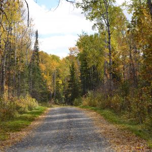
This road has the greatest variety of tree species found anywhere in the Beltrami Island State Forest. birch, aspen, silver maple, black and green ash, Balm of Gilead, bur oak, and basswood are all found along this road. Each add their own hue to nature’s palette in the fall. The period between September 20 and October 15 is the best time to enjoy this blaze of color.
The original Rapid River Road was formed when the south branch of the Rapid River was channelized with a dredge. The dredged soil was leveled and used for a road for the next 60 years. This portion of the road was rerouted in 1986 because the river was nibbling away at the road base.
The old road segments make great walking trails along the river. These segments form loops that begin and end on the present road. This is a prime opportunity to view wildlife.
The bridges on the Rapid River Forest Road are named after the settler that homesteaded the land nearest the location of the bridge. They include the Schuh, Pepin and Pete’s bridges. Other sites of historical interest along the Rapid River Forest Road are the Konigson Logging Camp site, Lovedale community, Oaks Camp Works Project Administration site, and the Pepin homestead.
THE BOG DRIVE
The bog drive follows the Pitt Grade Forest Road from Cty. Rd. 3 on the north to the Rapid River Forest Road on the south. The Pitt Grade was built by leveling the spoil heap left when a drainage ditch was dug through the heart of the bog about 1915.
Although the land surrounding the ditch wasn’t suitable for farmland, homesteaders used to travel by the ditch grade road to get to the small community of Pitt where there was a railroad depot, post office, blacksmith shop, and several stores.
Today, the settlers are long gone and the Pitt Grade is now a quiet forest road. It travels through long stretches of tamarack, black spruce, and white cedar bog. When the road climbs slightly in elevation, the forest’s composition changes to aspen, Balm of Gilead, and birch. There is also a small stand of native white pine on a rise near the headwaters of the Baudette River. It is a surprise when the road drops down from the bog and encounters a river rimmed with ash and silver maple trees.
The Pitt Grade forest road crosses the North Branch of the Rapid River at the Lundeen Bridge and the South Branch of the Rapid River at the Schuh Bridge. The bridges are named after the people who homesteaded the land near the bridges.
Birdwatchers should watch for Spruce Grouse and Great Gray Owls. Both species of birds live along the Pitt Grade. Fishermen may wish to try for trout on the north end of the Pitt Grade. The ditch adjacent to the road is a designated trout stream in that area.
Bog plants provide a visual feast at certain times of the year. During June there are numerous wildflowers and flowering shrubs that bloom along the road. The most spectacular time of the year to travel this road is in the fall. Pick a sunny day around October 15th – there is nothing quite like the sight of bright chartreuse-colored tamaracks framed with the dark green of spruces under a brilliant blue sky!
FOREST MANAGEMENT DRIVE
Learn about forest management practices on a drive along the Stoney Corners Forest Road. The species of trees growing along the Stoney are the result of the area’s geology and fire history. Ancient Lake Agassiz left a series of gently rolling sandy ridges along the west half of the road. The east half of the road travels through a level area with poorly drained silty loam soils. The entire area surrounding the Stoney was burned by a catastrophic forest fire in 1930. As a result, almost all the trees growing along the Stoney today are less than 60 years old.
After the fire, the east end of the Stoney regenerated to aspen. Aspen is a hardwood tree that grows vigorously for 40-50 years and then slowly declines. Aspen stands are gradually harvested as they reach the end of their life cycle. Young aspen needs full sunlight to thrive. For that reason aspen is harvested by removing all the trees on a site except for snag trees left for cavity nesting birds. Sunlight then warms the forest floor and a new Aspen forest sprouts from the root systems of the harvested trees. A newly harvested area may look like a disaster but within a year it will become a dense thicket of new trees.
Aspen harvests are planned to benefit many species of wildlife by cutting blocks in a manner that creates a variety of differently aged aspen stands to be in close proximity of one another. You will see many examples of aspen stands in various stages of maturity along the Stoney.
The west end of the Stoney is forested mainly with jack pine and red pine trees. Both species of trees do well on the dry, sandy soils found there.
The red or Norway Pine will continue to grow vigorously for 100-120 years before its growth slows. It’s valuable for saw timber and poles when mature. Red pine stands are thinned periodically starting at about age 40. Thinning the stand reduces competition for sunlight, moisture, and nutrients for the remaining trees. Old homestead fields throughout the forest were planted with Red Pine by CCC and WPA workers in the 1930’s. Drive the Faunce Road between the Stoney and the Spina Forest Road to see what those plantations look like today.
Jack pine is the most common pine tree in the Beltrami Island State Forest. It matures at around 50 years of age. It only grows well in full sunlight. It is harvested by cutting entire blocks of trees. Harvested jack pine sites are nearly always hand planted back to pine to insure that sites are reforested. There are numerous jack pine stands along the Stoney that have been harvested and replanted within the past few years.
The trees harvested along the Stoney become a number of different wood products. Some logs go to local sawmills to become lumber, railroad ties, pallets, crating, and wire spools. Other logs become treated wood landscape timbers and fence posts. The red pine trees thinned from plantations often become log homes. Trees too small to be sawed become paper, cardboard, and sheets of flakeboard.
All timber harvests in the Beltrami Island State Forest are planned by wildlife managers and foresters. This cooperation insures that the forest will continue to provide recreation, productive home for wildlife, and wood products for our use.
BLUEBERRY PICKER’S DRIVE
The blueberry is a favorite wild summer fruit. It is found as part of the plant community growing on the sandy beach ridges that glacial Lake Agassiz left behind as it retreated northward 10,000 years ago. 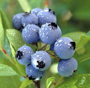
Look for blueberry bushes where jack pine trees are found. The best picking is usually along roadsides, in small forest openings, and any place the jack pine trees grow thinly enough that sunlight dapples the forest floor.
The heaviest berry crops occur on years with ample rainfall and no early June frosts while the berry plants are blooming. Look for the first ripe berries around the 4th of July. Berries will ripen continuously until about the first week of August.
Waters of the Dancing Sky Scenic Byway named for the Northern Lights that can often be seen dancing in the sky, this is Minnesota’s northernmost byway.
M.O.M.’S WAY
For the long-distance traveler, M.O.M’s Way is sure to appeal. Four hundred miles long, this journey takes you through Manitoba, Ontario, and (northern) Minnesota.
HOMESTEADERS HISTORIC DRIVE
The lure of free land drew people to the Lake of the Woods area after the turn of the century. For the payment of a filing fee, a settler could lay claim to 160 acres of land. After living on the land for 5 years and erecting a dwelling, the homesteader received a deed to the property. This process was known as “proving up.”
At one time 40 families lived along the present day Bankton Forest Road. They accessed the area on forest trails that followed sandy ridges. They also traveled by boat in the summer and on the ice in the winter.
The homesteaders’ livelihood was based on the resources of the area. They logged sawtimber and poles, worked in sawmills, trapped fur, and provided their own food by subsistence farming and hunting.
The community of Bankton had a post office, school, and a community hall. Most of the people that lived in the Bankton area relocated to other parts of Lake of the Woods county during the federal Resettlement Program of 1935.
The openings along the Bankton Forest Road are all vestiges of the farm fields left by the homesteaders. The location of the homesite is often marked with a willow tree or lilac bush planted by the settlers. Two cemeteries established by the homesteaders remain along the Bankton Forest Road. Records are a bit fuzzy, but at least 5 people are buried in each cemetery. The Hamilton Farm Cemetery is also referred to as the Germanson Cemetery in early township records. The Bankton Cemetery is called God’s Acre Cemetery in the obituary of one of the people buried there.
Informational signs along the Bankton Forest Road identify the two cemeteries and the location of a few of the homestead sites where evidence of buildings remain.
Lake of the Woods being so far north creates special opportunities to see variety that you may not see at home. For some, this is a highlight. For others, perhaps a break from fishing. Whatever the case, be sure to bring your camera!
To learn more about Lake of the Woods, check out the Lake of the Woods Tourism website.
To find lodging, check out our lodging page.
And for more Scenic Drives around Lake of the Woods