fbpx

SNOWMOBILING

snowmobiles1Snowmobiling the Lake of the Woods area, some of the best trails in the state.  Enjoy hundreds of miles of connected groomed trails. Our trails are true wilderness trails, as there is less than 5 miles of ditch riding on our trail system. Trails go as far up as the Northwest Angle, as far west as Warroad, south to Waskish and as far east as Big Falls and north up to International Falls.

To the west our trail system hooks up to the Roseau County groomed trails, as well as Kittson County groomed trails and on into North Dakota. To the south we hook up to Beltrami Island State Forest Trails, as well as hundreds of miles of logging trails.

Northwest Angle and Island areas are accessible from Lake of the Woods or the Can-Am Trail by snowmobile. To the east, the Northern Connection hooks up to the FILE4303-300x224groomed Voyageur Trail West and Arrowhead Trail. Our area is unique by having Lake of the Woods and Rainy River, which both provide ample ice riding.

Some of the trails on this map are funded by the DNR through the Grant-in-Aid program using license fees and gas tax monies. The State of Minnesota, Lake of the Woods County, Koochiching County and private landowners are the people that make our trails possible. The trails on the map cross property of many private citizens, as well as lands which are administered by various levels of government. We owe the landowners our thanks and must respect their property.

igloo-bar-Zippel-snowmobile-300x225
sunset-lodge-winterangle-inn-lodge-ice-sign

lake-of-the-woods-county-snowmobilingarnesens-fish-houses-121516snowmobilesportable-ice-snowmobile-winter-march-2014-300x168

In these parts, we get a lot of attention for the world class fishing.  What we don’t receive a lot of attention for is our incredible snowmobiling and well groomed and well marked snowmobile trails.


If you like to snowmobile, just think about this…

-There are staked and groomed snowmobile trails extending from Wheeler’s Point south to Baudette on the Rainy River, 42 miles north to the NW Angle and west to Warroad.

-273 miles of land trails on the south end of Lake of the Woods alone.

-Trails extend from Baudette east to Birchdale and then to Big Falls.  This is probably the most wilderness type trail in the state.  It goes for 87 miles one way and only crosses two roads.  There are gas stations in Birchdale and in Big Falls.  The stretch from Birchdale to Big Falls is 53 miles.  Snowmobiling NW Angle, Lake of the Woods

-They also extend west from Baudette to Williams, Zippel Bay State Park and over to Warroad.  You can also go south from on that trail and hit Roosevelt and enter part of Beltrami Island State Forest.

-Also extend from Baudette south all the way to Washkish.

-Don’t forget about the NW Angle.  Land trails extend through the wilderness from Angle Inlet throughout the northernmost point of the continental U.S.

We appreciate all who are responsible for our great snowmobile trails!  

In addition to local snowmobile clubs take great pride in opening and maintaining trails by grooming weekly, many make our snowmobiling so quality.  Some of the trails on this map are funded by the DNR through the Grant-in-Aid program using license fees and gas tax monies. The State of Minnesota, Lake of the Woods County, Koochiching County, Roseau County and private landowners are the people that make our trails possible. Trails cross property of many private citizens, as well as lands which are administered by various levels of government. We owe the landowners our thanks and must respect their property.

Snowmobile Shelters

There are seven different shelters available to snowmobilers along the trail.  These are for both safety and an area to take a break, warm up or simply regroup with your party.

7 Mile Shelter:  
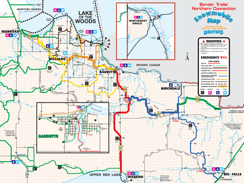
7 miles south of Baudette at trail junction.


 7 mile shelter
Pitt Y Shelter:  10 miles south of Pitt at trail junction.

 pitt shelter
Graceton Shelter:  Between Williams and Baudette.

 graceton shelter

Floyd Olson Shelter:  On the Floyd Olson Trail up to Rocky Point and Long Point.


 floyd olson shelter
Twin Pines Shelter:  Approximately 35 miles SE of town.

 twin pines shelter
County Line Shelter:  20 miles south on the LoW / Beltrami County line.

 county line shelter

Garden Island Shelter:  
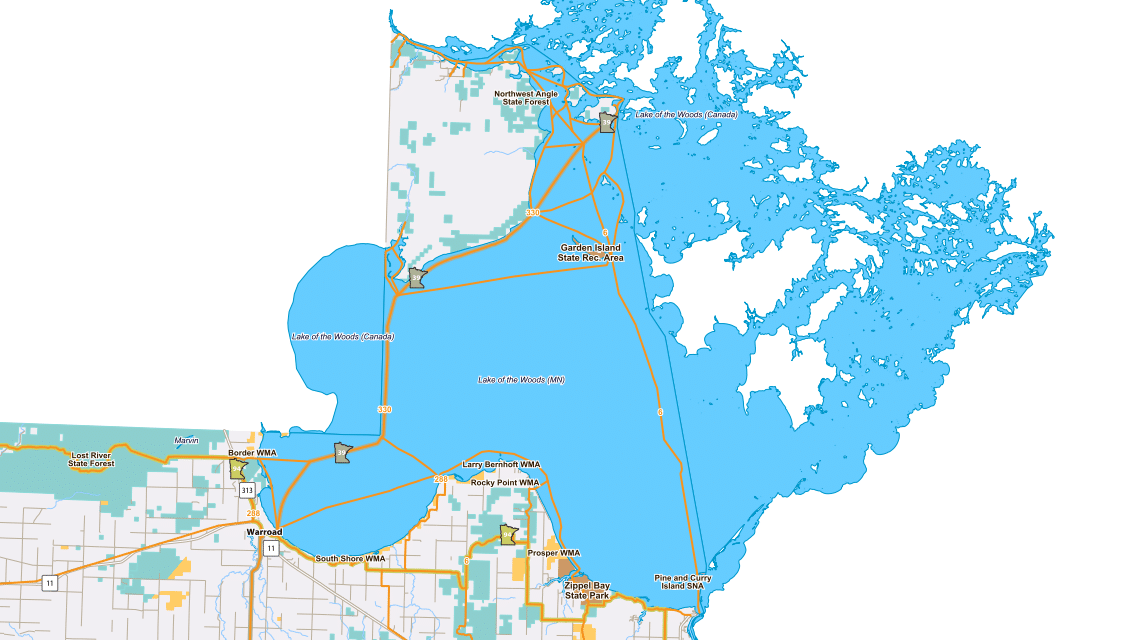
Located on Garden Island.


 garden island shelter

Snowmobile Trail Maps.  

Snowmobile trails 121621snowmobilemap_sm-1-768x576baudette-city-snowmobile-map-2006
In these parts, ice fishing gets most of the attention, and for good reason.  After all, we are The Walleye Capital of the World.  A little secret, the snowmobiling is world class.  Because we don’t get a ton of snowmobilers like other more snowmobile popular areas, the trails aren’t beat down so hard.  This leads to some awesome snowmobiling amongst some of the most beautiful scenery found anywhere.
If you are interested in snowmobiling Lake of the Woods, check out one of our over 60 options for lodging.
Don’t forget about our lodging availability finder on busy weekends.  Simply enter your contact info, the dates you are interested in and what part of the area you would like to stay and an email is automatically sent to the many resorts, hotels and outfitters in the area and if they have openings or a cancellation, they will contact you back.  This is a nice way to find lodging during the most popular times.
If you are a snowmobiler, we encourage you to try the Lake of the Woods area for a change of pace.  We like to call it a hidden gem!
Have a map mailed to you by filling out our information request form.

Find more information on The Lake Of The Woods Drifters Snowmobile Club.
Call 218-634-3042 for the latest trail conditions and club activities.

For more info on snowmobiling in the NW Angle, contact NW Angle Edge Riders

Click Here for the MN DNR Interactive Snowmobile Map

SNOWMOBILING MAPS

Start typing and press Enter to search