
MTT. Minnesota Tournament Trail
NWT. National Walleye Tour
AIM. Angler’s Insight Marketing
Chili Bowl, Border View Lodge
Arnesen’s, Summer Tournament
River Bend Resort, Ladies tournament
Zippel Bay Resort, Northern Pike Tournament
AND MORE!
The Northwest Angle is a well-kept secret location to most people. If you look at a map of Minnesota, you will see what is affectionately called…”The Chimney” of Minnesota. This particular parcel of land is part of Minnesota because of a surveyor’s mistake that happened years and years ago.
As a matter of fact, the Northwest Angle, the most northerly point in the contiguous 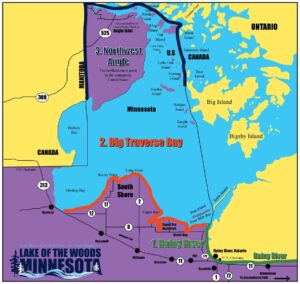
This does not hinder the avid fisherman/tourism who wants to fish these waters close to Canada for walleye, perch, and Muskie among other species. This area also includes a few islands. You can visit Fort St. Charles, a historic spot, and also visit or stay at Oak Island or Flag Island. It must be noted that you must have a passport to travel in and out of Canada and also be checking in at Customs which is also a unique experience. This is done at Jim’s Corner which has been equipped with technology to allow you to check in remotely into Customs.

There is new happening at the Northwest Angle. Lake of the Woods County Board has approved a park Master Plan for the area and are working to secure grant funding for the project. The Northwest Angle will then be proud to see a “Northerly Park” be constructed for the area. The Grand Forks Herald and writer Brad Dokken has done a great job introducing the public with information about the formation of that park.
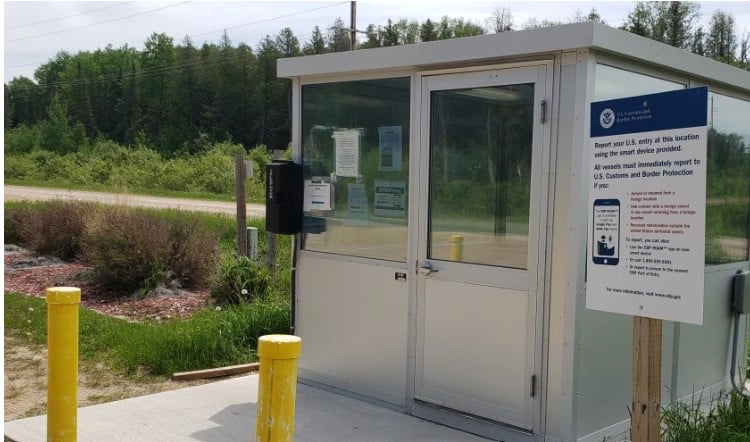
Jim’s Corner, will be the site for the Northerly Park on Minnesota’s Northwest Angle. The park will include a visitor center, among other amenities, to replace the remote border-crossing checkpoint currently in place at Jim’s Corner as shown by this 2021 picture.
The Master Plan for the new park on Minnesota’s Northwest Angle has been finalized, and the project is now moving from concept to implementation. The “Northerly Park,” as it’s called, will be the first park at the Northwest Angle and the northernmost park in the Lower 48.
According the public works director for Lake of the Woods County in Baudette, Minnesota, the Lake of the Woods County Board approved the Master Plan for the park at its most recent meeting in late November.
Lake of the Woods County in early 2024 contracted with consulting firm Houston Engineering to complete a Master Plan for the Northerly Park. The county board’s approval of the plan is an exciting step forward for the project.
A group of nine people, mainly Northwest Angle residents, have worked with Houston Engineering to develop the plan. It included two phases of public engagement, both in person and virtually, to develop a list of amenities the park should include.
To date, the ideas for the park include such amenities as a visitor center – either staffed or unstaffed, a lookout tower, interpretive signage, an elevated boardwalk and a dock.
Northerly Park will be situated on 160 acres of county-owned land that includes Jim’s 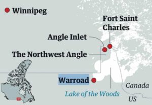
A display at Jerry’s Restaurant and Lounge on Minnesota’s Northwest Angle during the public engagement process highlighted some of the likely features that could be incorporated into the Northerly Park that’s being planned on 160 acres of land owned by Lake of the Woods County.
A visitor center that will be patterned after historic Fort St. Charles on Magnuson Island, a viewing tower, playgrounds, paved and gravel trails, pavilion, boardwalk, floating dock, a kayak and canoe launch, signage and vault toilets are among the amenities included in the final Master Plan.
Securing funding for the park is next. The estimated cost for the entire project is just over $2.5 million, according to the final Master Plan. The park’s features will likely be added in phases as funding becomes available.
Minnesota Department of Natural Resources, Minnesota Department of Transportation, U.S. Department of Agriculture, Minnesota Historical Society and various foundations are among possible grant sources listed in the Master Plan. It is hoped that construction would most likely begin in 2026 rather than 2025, as the timeline for planning and permitting would extend beyond the 2025 season.”
Lake of the Woods historian Joe Laurin (second from left) talks about the history of Fort St. Charles on Minnesota’s Northwest Angle on Thursday, Sept. 15, 2022.
Joe Laurin is a Flag Island resident and member of the steering committee and he said he expects a visitor center will be among the first features at the park, along with improved parking and trails, some of which are already in place. A visitor center, he says, will help streamline the process for first-time visitors entering or leaving the Angle.
In addition, Northerly Park will further expand the Angle’s offerings beyond fishing and the Northernmost Point Buoy that’s patterned after the Southernmost Point Buoy in Key West, Florida, Laurin said.
For more information see www.lakeofthewoodsmn.com/northwest-angle
Click on our Lodging page at: www.lakeofthewoodsmn.com/Lodging
See our facebook page at: www.facebook.com/lakeofthewoodsmn
